
INFORMATION ON AIS
Basics of AIS
AIS stands for "Automatic Identification System". AIS devices (e.g.: the Nauticast A2 Class A AIS transponder or the Nauticast B2 Class B AIS transponder) permanently send and receive standardized digital messages with significant ship information such as vessel name, MMSI, callsign and navigational data on two exclusively reserved channels of the marine radio band (channel 87B 161.975 MHz and channel 88B 162.025 MHz). This allows vessels to be identified without eye contact and their position to be located at night, in bad weather, at blind spots of the radar or at a great distance. AIS devices thereby increase the safety of navigation and help to avoid collisions. For the participation in the AIS network only a working AIS device is necessary.
AIS is a worldwide standard based essentially on 2 pillars:
- International Telecommunication Union (ITU) radio standards define technical characteristics and communication rules both for the VHF and for the data link. Current standards are ITU-R M.1371-5, M.825-3 and M. 1084-5.
- International Maritime Organization (IMO) defines the functional standards of operation and objectives of AIS in IMO Resolution MSC.74 (69) Annex 3.
AIS devices are part of the Global Maritime Distress and Safety System (GMDSS).
How AIS works
The AIS standard is not only supported by devices on ships, but increasingly also on land by base stations, on marine and river infrastructure such as buoys, offshore platforms, on aircraft in the framework of sea rescue operations and as a personal safety device.
The AIS network also includes AIS base stations, typically placed on the shore and along rivers. AIS devices are also used on marine and river infrastructure such as buoys, offshore platforms, on aircraft in the framework of sea rescue operations and as a personal safety device. When satellites are used to detect AIS signals, the term Satellite-AIS (S-AIS) is used.
The following exhibit illustrates a typical AIS network in which multiple AIS-equipped stations on ships, on land and in the air communicate with each other.
(drawing shows our older model Nauticast AIS, now replaced by the Nauticast A2 Class A AIS Transponder)
Components of an AIS device
Each AIS Class A and Class B device consists of
- one VHF transmitter,
- two VHF receivers,
- one VHF DSC receiver (separate receiver for Class A and mostly shared on Class B devices)
- an internal positioning module based on a global navigation satellite system (GNSS), e.g., GPS, GALILEO, Baidu or GLONASS. On larger vessels with class A AIS, the internal positioning module is only used as a fallback and position and movement information are normally taken from dedicated sensors (GPS, compass) via the NMEA link, as they provide higher accuracy.
Additionally, each Class A device includes
- standard marine electronic communication links (IEC 61162/NMEA 0183) to sensors (such as a GPS receiver, gyrocompass or rate of turn indicator) and electronic chart displays (ECDIS),
- a minimum keyboard and display (MKD),
- and a standard communication link for the marine pilot (Pilot Plug).
AIS communication in detail
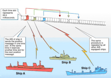
ITU (International Telecommunications Union) defines the principles of VHF transmission and slot allocation in its Recommendation ITU-R M.1371 (current version -5): “Technical characteristics for an automatic identification system using time division multiple access in the VHF maritime mobile frequency band”.
Transmissions use 9600 bit GMSK FM modulation over 25kHz channels using HDLC packet protocols.
At the center of an AIS network is its TDMA (time division multiple access) scheme, using a so-called slot map. 60 seconds (= 1 frame) are sliced into 2250 time slots to fit one VHF-report from an AIS station. As 2 channels are used the total number of time slots is 4500 in 60 seconds. There are different ways to participate in the slot reservation mechanism, described in the next section. Contrary to the name there is not one slot map and nothing like a central slot map, but essentially all participating AIS stations will store and update their own slot map based on AIS data received and their calculations. For being in sync with "the slot map" it is also essential that the AIS has reliable GPS information as the exact time is derived from there.
The VHF-coverage range of AIS is similar to other VHF applications and will essentially depend on the height the VHF antenna is mounted and on transmission power. Its propagation is slightly better than that of radar, due to the longer wavelength, so it’s possible to “see” around bends and behind islands if the land masses are not too high. Under optimal conditions the AIS range can stretch to 30-50 nm for a class A device sending with 12.5W. A typical class B range (2W) would be 6-9 nm, even more depending on position and installation of the VHF-antenna.
The capacity of the system was thought to be nearly unlimited, allowing for a great number of ships to be accommodated at the same time. But in recent years with increased traffic, more devices and bandwidth also used up by new applications, AIS channels have become overloaded in busy harbors and routes.
Thus, the next generation system (VDES) is planned to improve these situations.
Channel access schemes
SOTDMA
Self-organized time division multiple access (SOTDMA) is the most complex reservation scheme and mandatory for Class A AIS devices. Slot selection by an AIS station is randomized within a defined interval and tagged with a timeout of between 0 and 8 frames (1 frame = 1 minute). When a station changes its slot assignment, it pre-announces both the new slot and the timeout for the reservation. In this way new stations, including those stations which come within radio range, will always be received by nearby vessels.
The SOTDMA broadcast mode allows the system to be overloaded by 400 to 500% through sharing of slots, and still provide nearly 100% throughput for ships closer than 8 to 10 NM to each other in a ship to ship mode. In the event of system overload, only targets further away will be subject to drop-out.
RATDMA
Random access time-division multiple access (RATDMA) is generally used to allocate a slot, that was not pre-announced. It uses a random slot in a 4s interval, that has not been pre-announced by another station. This access scheme is used by all devices for non-repeating messages, only an AIS AtoN may use it for all transmissions.
FATDMA
Fixed access time division multiple access (FATDMA) should be used by base stations only. FATDMA allocated slots should be used for repetitive messages. Additionally, AIS AtoN stations Type 1 and 2 may use FATDMA for transmissions (using slots allocated by a base station for AIS AtoNs).
ITDMA
Incremental time division multiple access (ITDMA) allows a station to pre-announce transmissions. It is used for data link entry, temporary changes and transitions in periodical reporting intervals and pre-announcement of safety related messages.
CSTDMA
Carrier sense time division multiple access (CSTDMA) is usually used by AIS Class B devices, called Class B "CS". The device monitors the AIS transmissions to determine if its planned transmission slot is free of activity. The transmission is done a few milliseconds after other devices to allow for this monitoring. If the slot is not used by any other station the device initiates its transmission. The Class B “CS” unit is also required to listen for reservation messages and comply with these reservations. This polite operation ensures that a Class B “CS” will be interoperable and will not interfere with equipment that operates with SOTDMA.
AIS message types
|
Message ID |
Name |
Description |
Access scheme |
|
1 |
Position report |
Scheduled position report; (Class A) |
SOTDMA, RATDMA, ITDMA |
|
2 |
Position report |
Assigned scheduled position report; (Class A) |
SOTDMA |
|
3 |
Position report |
Special position report, response to interrogation; (Class A) |
RATDMA |
|
4 |
Base station report |
Position, UTC, date and current slot number of base station |
FATDMA, RATDMA |
|
5 |
Static and voyage related data |
Scheduled static and voyage related vessel data report; (Class A) |
RATDMA, ITDMA |
|
6 |
Binary addressed message |
Binary data for addressed communication |
RATDMA, FATDMA, ITDMA |
|
7 |
Binary acknowledge-ment |
Acknowledgement of received addressed binary data |
RATDMA, FATDMA, ITDMA |
|
8 |
Binary broadcast message |
Binary data for broadcast communication |
RATDMA, FATDMA, ITDMA |
|
9 |
Standard SAR aircraft position report |
Position report for airborne stations involved in SAR operations, only |
SOTDMA, RATDMA, ITDMA |
|
10 |
UTC/date inquiry |
Request UTC and date |
RATDMA, FATDMA, ITDMA |
|
11 |
UTC/date response |
Current UTC and date if available |
RATDMA, ITDMA |
|
12 |
Addressed safety related message |
Safety related data for addressed communication |
RATDMA, FATDMA, ITDMA |
|
13 |
Safety related acknowledge-ment |
Acknowledgement of received addressed safety related message |
RATDMA, FATDMA, ITDMA |
|
14 |
Safety related broadcast message |
Safety related data for broadcast communication |
RATDMA, FATDMA, ITDMA |
|
15 |
Interrogation |
Request for a specific message type |
RATDMA, FATDMA, ITDMA |
|
16 |
Assignment mode command |
Assignment of a specific report behaviour by competent authority using a Base station |
RATDMA, FATDMA |
|
17 |
DGNSS broadcast binary message |
DGNSS corrections provided by a base station |
FATDMA, RATDMA |
|
18 |
Standard Class B equipment position report |
Standard position report for Class B shipborne mobile equipment to be used instead of Messages 1, 2, 3 |
SOTDMA, ITDMA, CSTDMA |
|
19 |
Extended Class B equipment position report |
No longer required; extended position report for Class B shipborne mobile equipment; contains additional static information |
ITDMA |
|
20 |
Data link management message |
Reserve slots for Base station(s) |
FATDMA, RATDMA |
|
21 |
Aids-to-navigation report |
Position and status report for aids-to-navigation |
FATDMA, RATDMA |
|
22 |
Channel management(6) |
Management of channels and transceiver modes by a Base station |
FATDMA, RATDMA |
|
23 |
Group assignment command |
Assignment of a specific report behaviour by competent authority using a Base station to a specific group of mobiles |
FATDMA, RATDMA |
|
24 |
Static data report |
Additional data assigned to an MMSI Part A: Name Part B: Static Data |
RATDMA, ITDMA, CSTDMA, FATDMA |
|
25 |
Single slot binary message |
Short unscheduled binary data transmission (Broadcast or addressed) |
RATDMA, ITDMA, CSTDMA, FATDMA |
|
26 |
Multiple slot binary message with Communi-cations State |
Scheduled binary data transmission (Broadcast or addressed) |
SOTDMA, RATDMA, ITDMA FATDMA |
|
27 |
Position report for long-range applications |
Class A and Class B “SO”outside base station coverage |
MSSA |
|
28-64 |
Undefined |
Reserved for future use |
|
Reporting intervals
The different information types are valid for different time periods and thus need different update intervals.
Static information: Every 6 min or when data has been amended and when interrogated. The long intervall between transmissions of static information is the reason, why other AIS stations are only seen with their MMSI when an AIS is switched on until the first report with static information is received.
Dynamic information: Dependent on speed and course alteration according to the tables below.
Voyage related information: Every 6 min or when data has been amended and when interrogated.
Safety related messages: As required.
Class A reporting intervals:
|
Dynamic conditions |
Nominal reporting interval |
|
Ship at anchor or moored and not moving faster than 3 knots |
3 min |
|
Ship at anchor or moored and moving faster than 3 knots |
10 s |
|
Ship 0-14 knots |
10 s |
|
Ship 0-14 knots and changing course |
3 1/3 s |
|
Ship 14-23 knots |
6 s |
|
Ship 14-23 knots and changing course |
2 s |
|
Ship > 23 knots |
2 s |
|
Ship > 23 knots and changing course |
2 s |
Other AIS devices' reporting intervals:
|
Platform’s condition |
Nominal reporting interval |
Increased reporting interval |
|
Class B “SO” not moving faster than 2 knots |
3 min |
3 min |
|
Class B “SO” moving 2−14 knots |
30 s |
30 s |
|
Class B “SO” moving 14−23 knots |
15 s |
30 s |
|
Class B “SO” moving > 23 knots |
5 s |
15 s |
|
Class B “CS” not moving faster than 2 knots |
3 min |
– |
|
Class B “CS” moving faster than 2 knots |
30 s |
– |
|
Search and rescue aircraft (airborne mobile equipment) |
10 s |
– |
|
Aids to navigation (AIS AtoN) |
3 min |
– |
|
AIS base station |
10 s |
– |
The increased reporting intervals are used in a crowded area (more than 50% of the slots used).
AIS device types
To a large degree all AIS devices are compatible. They use the same frequencies and can access the TDMA slots. However, some special messages will be reserved for certain types of AIS and different channel access schemes may be used.
Class A (IEC 61993-2)
Shipborne mobile equipment intended to meet the performance standards and carriage requirements adopted by IMO. Transmission power normally is 12.5W. Class A stations report their position (message 1/2/3) autonomously every 2-10 seconds dependent on the vessel’s speed and/or course changes (every three minutes when at anchor or moored). The vessel’s static and voyage related information (message 5) is transmitted every 6 minutes. Class A stations are also capable of text messaging safety related information (message 12/14) and AIS Application Specific Messages (message 6/8/25/26), such as meteorological and hydrological data, electronic Broadcast Notice to Mariners, and other marine safety information (see IMO Safety of Navigation Circular 289, Guidance on the use of AIS application-specific messages (ASM) or the IALA Application Specific Message Collection). In professional shipping the AIS should be switched on at all times according to most regulations, also when the vessel is stationary or loading.
One of the most successful class A transponders fulfilling Inland and Solas requirements is our Nauticast A2 as it fulfills all international standards and is operating flawlessly in maritime, coastal and inland waters.
Class B (IEC 62287-1 & IEC 62287-2)
Shipborne mobile equipment which is interoperable with all other AIS stations but follows simpler performance standards. The transmission power of 2W for Class B devices is significantly lower than for Class A or Base stations, consequently the position of the VHF antenna is by far the most decisive factor for a good transmission range. Similar to Class A stations they report their position (message 18) every three minutes when at anchor or moored. But it is reported less often than Class A when moving. Likewise, they report the vessel’s static data (message 24A and 24B) every 6 minutes, but not any voyage related information. They can receive safety related text and application specific messages, but cannot transmit them.
There are two types of Class B AIS, those using Carrier Sense Time Division Multiple Access (CSTDMA) technology and those using Self Organizing Time Division Multiple Access Technology (SOTDMA). Class B "SO" uses a more elaborated time slot reservation methodology and needs more processor power for slot calculations. Class B "CS" is generally less expensive. In practice the differences are rather negligible. The Nauticast B2 offers class A like reception of 50 km and higher and will be received at distances of up to 20 km under good conditions. With its reliability, a variety of communication options and a powerful management software it is the choice of the ambitious and prudent yachtsman.
Search and Rescue Aircraft (partly IEC 61993-2)
Aircraft mobile equipment, normally reporting its position every ten seconds (message 9). Static data can be transmitted using messages 5, 24A and 24B.
AIS AtoN station (Aid To Navigation) (IEC 62320-2)
An AtoN station may be fixed (shore) or floating (maritime or river) providing location and status of an Aid to Navigation (AtoN). Normally it reports (message 21) every three minutes, but here the standard offers a lot of flexibility for adjustment to individual requirements. These stations may also broadcast Application Specific Messages (message 12/14). The station may also transmit messages 21 for virtual or synthetic AtoNs.
AIS search and rescue transmitter (SART) (IEC 61097-14)
Mobile equipment to assist homing to itself (i.e. life boats, life raft). An AIS SART transmits a text broadcast (message 14) of either 'SART TEST' or 'ACTIVE SART'. When active the unit also transmits a position message (message 1 with a 'Navigation Status' = 14) in a burst of 8 messages once per minute.
AIS SARTs are also used in maritime survivor locating devices (MSLD) or man overboard (MOB) devices, as specified in RTCM 11901.1, Standard for Maritime Survivor Locating Devices as well as for AIS locating beacons on 406 MHz EPIRBs. Standard AIS SARTs can be identified by MMSI's beginning with the numbers "970", AIS maritime survivor locating devices or MOBs with MMSIs beginning with "972", and AIS EPIRB with MMSIs beginning with "974". All categories of AIS SARTs will be displayed on IMO-mandated shipboard navigation displays.
AIS base station (IEC 62320-1)
Shore-based station providing AIS channel management, text messages, time synchronization, meteorological or hydrological information, navigation information, or position of other vessels. Normally reports (message 4) every ten seconds. These stations are normally operated by the responsible authorities for the area. With the spread of applications like Marinetraffic.com, vesselfinder.com, shipfinder.com a lot of privately run "base stations" came into operation. However, these are more like large "receiver networks" with huge databases and will not transmit or assign and control other AIS stations as base stations run by the authorities would do.
Applications, benefits and limitations
The benefits of AIS Transponders in a few words:
- AIS improves the safety at sea
- The problem with Radar shadows does not apply for AIS
- The functionality of AIS is not impaired by bad weather conditions
- Used together with radar the AIS significantly improves safety of crew, ship, and cargo.
Collision avoidance
AIS was developed by the IMO technical committees as a technology to avoid collisions among large vessels at sea. The technology identifies every vessel individually, along with its specific position and movements, giving a regional overview in real time.
While requirements of AIS are to display only very basic text information, the data obtained can be integrated with electronic navigational charts (ENC), complete electronics chart display systems (ECDIS), radar displays or a combination of them, providing consolidated navigational information.
When a ship is navigating at sea, information about the movement and identity of other ships in the vicinity is critical for navigators to make decisions to avoid collision with other ships and dangers (shoal or rocks). Visual observation (unaided, binoculars and night vision), audio exchanges (e.g., whistle, horns, and VHF radio), and radar or Automatic Radar Plotting Aid are historically used for this purpose. Their scope has not been replaced, but hugely augmented by the integration of AIS.
Vessel traffic services
In busy waters and harbors, a local vessel traffic service (VTS) may exist to manage ship traffic. Here, AIS provides additional traffic awareness and information about the configuration and movements of ships.
Fishing fleet monitoring and control
AIS is widely used by national authorities to track and monitor the activities of their national fishing fleets. AIS enables authorities to reliably and cost effectively monitor fishing vessel activities along their coast line, typically out to a range of 60 miles (depending on location and quality of coast based receivers/base stations) with supplementary data from satellite based networks.
Search and rescue
For coordinating on-scene resources of a marine search and rescue (SAR) operation, it is imperative to have data on the position and navigation status of other ships in the vicinity. In such cases, AIS can provide additional information and enhance awareness of available resources, even if the AIS range is limited to VHF radio range. The AIS standard also provisioned the use on SAR aircraft and included a message (AIS Message 9) for aircraft to report their position.
To aid SAR vessels and aircraft in locating people in distress, the specification (IEC 61097-14 Ed 1.0) for an AIS-based SAR transmitter (AIS-SART) was developed by the IEC´s TC80 AIS work group. AIS-SART was added to Global Maritime Distress Safety System regulations effective January 1, 2010. AIS-SARTs have been available on the market since at least 2009.
Accident investigation
AIS information received by VTS is important for accident investigation since it provides accurate data on time, identity, GPS-based position, compass heading, course over ground, speed (by log/SOG), and rates of turn, rather than the less accurate information provided by radar.
Messaging (Application Specific Messages - ASM)
AIS messages 6, 8, 25 and 26 provide possibilities to transmit binary messages. These may either be addressed at one or several MMSI (addressed messages (ABM) or or to all recipients (broadcast message –BBM). If not encrypted the message content may be decoded by any receiver. The use of ASM is rapidly increasing and ranges from navigational information like meteorological and hydrological data to traffic control, interrogations by base stations, cargo information, lock and other infrastructure status. AtoNs use ASM for all sorts of transmissions from sensor data to internal light or battery status. A future field is the use of ASM for traffic management, lock or harbor reservations, cargo handling, border controls and many more. The inventory of ASM is kept with IALA (the International Association of Marine Aids to Navigation and Lighthouse Authorities). See: http://www.iala-aism.org/asm/
All Nauticast products support the use of ASM and offer a wide range of encrypted communication. The Nauticast AtoN and class B products together with Link2AIS as a management plattform have been optimized for this purpose.
The future of AIS - VHF Data Exchange System (VDES)
While AIS capacity was deemed merely unlimited at its inception, AIS data channels have become overloaded in busy areas in recent years. Adding a huge appetite for future applications like ASM (see chapter above) it is now evident that AIS bandwidth is not sufficient any more. Another perceived shortcoming of AIS is its limited communication range.
Diese wachsenden Kommunikationsanforderungen machen die Entwicklung eines neuen Standards notwendig, der die derzeitigen AIS Kapazitäten erweitert. Das neue System umfassst nach wie vor AIS wie wir es heute kennen und nennt sich VHF Data Exchange System (VDES). VDES fügt 2 weitere terrestrsche Kanäle für ASM zu den derzeit verwendeten AIS Kanälen und bekommt eine 2-Weg Satellitenverbindung, sodass eine Vielzahl neuer Anwendungen sowohl für Schiffseigner als auch für Behörden möglich werden. Während der Standard ITU-R M.2092-0 “Technical characteristics for a VHF data exchange system in the VHF maritime mobile band” fertig ist und die terrestrischen Kanäle erfolgreich auf der World Radio Conference in 2015 weltweit zugeteilt wurden, gibt es immer noch keine Vereinbarung bezüglich der geplanten Frequenzen für den SAT-Link. Dies ist nunmehr für die WRC 2019 geplant, sollte dort allerdings die internationele Vereinbarung scheitern, so würde dies die Einführung von VDES um mehrere Jahre verzögern.
Ein ausführliche Zusammenfassung des VDES Konzeptes, den aktuellen Stand und geplante Aktivitäten findet man im IALA VHF Data Exchange System (VDES) Überblick (Englisch).